About the Conference
Earth Observation and Continuous Monitoring of Our Changing Planet: From Sensors to Decisions
Conference Overview
A joint meeting of the 21st William T. Pecora Memorial Remote Sensing Symposium (Pecora 21) and the 38th International Symposium on Remote Sensing of Environment (ISRSE-38) will convene in Baltimore, Maryland, USA from October 6 – 11, 2019. The combined conference will be hosted by NASA, NOAA and the USGS, with an overarching theme of “Earth Observation – Continuous Monitoring of Our Changing Planet: From Sensors to Decisions.”
Pecora 21 is the latest in a series of Symposia named after William T. Pecora, the USGS Director who helped initiate the Landsat program in the 1960s. The Pecora Symposium series was established by the USGS and NASA in the 1970s as a forum to foster the exchange of scientific information and results derived from applications of Earth observing data to a broad range of land-based resources, and to discuss ideas, policies, and strategies concerning land remote sensing. Pecora 21 will play host to a range of remote sensing experts and scientists from federal agencies, non-governmental organizations, universities and industry. The technical program will focus on both science and operational applications, emerging challenges and opportunities in working with Earth observations, and the role of partnerships in addressing scientific research, technical advancements and societal solutions. The William T. Pecora Award, presented annually to individuals or groups that make outstanding contributions toward understanding the Earth by means of remote sensing, will also be presented to the 2019 winners at a special session during the Symposium.
ISRSE convened for the first time in 1962 by the Willow Run Laboratories (later the Environmental Research Institute of Michigan (ERIM)) in Ann Arbor, Michigan, USA. ISRSE thus has the distinction of being the world’s first remote sensing conference. It is currently convened on a biennial basis by the International Centre on Remote Sensing of Environment (ICRSE) and the International Committee on Remote Sensing of the Environment (ICORSE) (a standing committee of the International Society of Photogrammetry and Remote Sensing). ISRSE is widely acknowledged to be one of the most significant gatherings of the international remote sensing community. The Symposium attracts senior staff of space agencies and international Earth observation programs, and is renowned for its application focus in developed and developing countries thereby providing a global overview of advances in Earth observation and the consequential societal benefits.
The joint hosting of these two prestigious remote sensing meetings will afford many unique opportunities for interaction and collaboration among a diverse and international community of remote sensing experts and scientists.
When
10/6/2019 7:00 AM – 10/11/2019 11:59 PM
Where
Baltimore Marriott Waterfront Hotel
700 Aliceanna Street
Baltimore, MD 21202 United States
Important Dates
Call for Session Ideas: September 2018
Session Ideas Due: October 2018
Call for Abstracts: November 2018
Abstracts Due: March 2019
Speaker Notification: April 2019
Preliminary Program: May 2019
Final Program: July 2019
Conference: October 2019
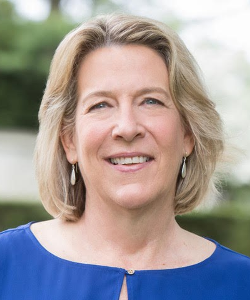
Conference Chairperson
Barbara Ryan
Barbara Ryan served as the Secretariat Director of the international Group on Earth Observations (GEO) until 2018 where she worked tirelessly to make Earth observation data more accessible and usable. GEO is an intergovernmental organization with over 100 member countries and over 100 participating partners working to integrate Earth observations comprehensively to understand how environmental factors impact human life and the environment. Under Ryan's leadership, millions of satellite images have been made available to the public at no charge allowing scientists, planners and policy makers to take a comprehensive approach to problems that transcend political boundaries including agriculture, biodiversity, climate change, disaster planning, energy and health. Ryan was previously the Director of the Space Program at the World Meteorological Organization (WMO) and Associate Director of Geography at the United States Geological Survey (USGS). She has also served as Chair of the Committee on Earth Observation Satellites (CEOS).
Keynote Speakers
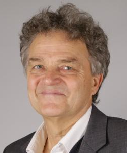
Gilberto Camara
Dr. Gilberto Câmara is a Brazilian researcher in Geoinformatics, Spatial Analysis, Land Use Change, and Nature-Society Interactions, from Brazil's National Institute for Space Research (INPE). He is internationally recognized for promoting free access for geospatial data and for setting up an efficient satellite monitoring of the Brazilian Amazon rainforest. Gilberto has advised 25 PhD dissertations and 31 Master thesis and published more than 230 scholarly papers that have been cited more than 11000 times (Google Scholar, May 2019). Gilberto was INPE’s assistant director for Earth Observation (2001-2005), and INPE’s director general (2005-2012). He is currently Secretariat Director for the Group on Earth Observations (GEO). As recognition for his work, he was inducted as a Doctor honoris causa from the University of Münster (Germany) and as a Chevalier (Knight) of the Ordre National du Mérite of France. He received the William T. Pecora award from NASA and the USGS for “leadership to the broad and open access to remote sensing data".
Michael Freilich
Dr. Michael Freilich is an accomplished oceanographer, microwave remote sensing expert, educator, and science administrator who directed NASA’s Earth Science Division from November 2006 through February 2019. Prior to his service at NASA, Freilich was Professor and Associate Dean at Oregon State University (1992-2006) and a researcher and satellite mission principal investigator at the Jet Propulsion Laboratory (1983-1991).
Freilich’s scientific research focuses on the use of spaceborne instruments to understand upper-ocean and air-sea interaction processes that couple our planet’s two great fluid systems and define the Earth’s environment. As Director of NASA’s Earth Science Division, he led the revitalization of NASA’s fleet of Earth observing research missions. During Freilich’s tenure leading NASA’s response to the inaugural Earth Science and Applications Decadal Survey, he introduced significant programmatic innovations including the use of SmallSats and CubeSats for science; developed new partnerships with the growing private sector space industry; expanded and strengthened interagency and international collaborations; created the Venture-Class program of PI-led, low-cost, competed missions; and – in collaboration with colleagues at USGS – established and gained Administration and Congressional funding for the multi-mission, multi-decadal, NASA-USGS Sustainable Land Imaging program.
An elected Fellow of the American Meteorological Society and 2004 recipient of the AMS Verner E. Suomi Award, Freilich has received national and international recognition, including the NASA Distinguished Service Medal, the Distinguished Presidential Rank Award for Senior Executives, NASA’s Distinguished Achievement Award and Public Service Medal, the European Space Agency’s Remote Sensing Certificate, and the Director’s Research Achievement Award from the Jet Propulsion Laboratory.
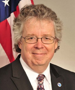
Stephen Volz
Assistant Administrator for Satellite and Information Services
Dr. Volz has 26 years of professional experience in aerospace. He is a leader in the international Earth observation community, serving as the NOAA Principal to the Committee on Earth Observation Satellites (CEOS). In this capacity he leads efforts to coordinate global satellite- based observations among international space agency partners to further the development of a Global Earth Observation System of Systems. He serves as the Co-Chair of the NOAA Observing Systems Council and is also a member of the NOAA Executive Council. Dr. Volz previously served as the Associate Director for Flight Programs in the Earth Science Division of NASA’s Science Mission Directorate where he managed all of NASA’s Earth Science flight missions and associated activities.
Prior to serving as the Flight Program Director, Dr. Volz was the Earth Science program executive for a series of Earth Science missions, including EO-3 GIFTS, CloudSat, CALIPSO, and ICESat, and he led the Senior Review for the Earth Science operating missions. Dr. Volz worked in industry at Ball Aerospace and Technologies Corporation from 1997–2002, where he was the Project Manager for the Space Infrared Telescope Facility superfluid helium cryostat and other flight projects. From 1986–1997 Dr. Volz worked for NASA’s Goddard Space Flight Center as an instrument manager, an IT Manager, a systems engineer, and a cryogenic systems engineer on missions and instruments including the Cosmic Background Explorer (COBE), among others.
Dr. Volz is a member of several professional societies, including the American Physical Society (M’82), the American Astronomical Society (M’87), the American Geophysical Union (M’02), and the American Meteorological Society (M’08). He is a senior member of the Institute of Electrical and Electronics Engineers (IEEE), an active member of and participant in the Geoscience and Remote Sensing Society (GRSS), and a member of the GRSS Administration Committee (AdCom) for the period of 2013–2017.

Katie Baynes
Systems Architect for the Earth Science Data Information System (ESDIS)
Katie Baynes is a Systems Architect for the Earth Science Data Information System (ESDIS) project, the management component of the Earth Observing System Data and Information System (EOSDIS). She has spent the past decade working on large-scale metadata cataloging systems, including the EOSDIS Common Metadata Repository search.earthdata.nasa.gov. She currently manages the Global Imagery Browse Services system worldview.earthdata.nasa.gov and oversees several commercial cloud migration efforts for the ESDIS project, including the Cumulus ecosystem. In addition to this work, she is active in the Earth Science metadata curation community and is passionate about the open source software movement, working to bring software and data to the people. She holds a Bachelor's Degree in Computer Engineering from the University of Maryland, College Park and a Master's Degree in Computer Science from the Johns Hopkins University. She lives with her husband and two kiddos in Fulton, Maryland.
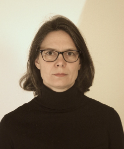
Doris Klein
Scientific Advisor at the German Remote Sensing Data Centre (DFD) of the German Aerospace Center (DLR)
Dr. Doris Klein is scientific advisor at the German Remote Sensing Data Centre (DFD) of the German Aerospace Center (DLR) since 2011. She received her PhD at Bonn University in 2008 and worked as PostDoc at the University of Würzburg. She is specialized in remote sensing with a focus on multisensory applications in the context of global change and climatic change. Additionally she is working as scientific coordinator of the FireBIRD Mission, a mission designed to detect wildfires. A special interest of Doris Klein are the new scientific opportunities which open up due to the multitude of Copernicus Sentinel and New Space data as well as the infrastructure solutions which are developed to cope with these data amounts.

Ian Schuler
CEO of Development Seed
Ian is CEO of Development Seed, impactful geospatial tools that empower our partners to track and understand a changing planet. We create, analyze and distribute massive amounts of data by leveraging machine learning to power AI in the cloud. From our work with NASA to use AI to classify hurricanes as imagery comes off the satellite–to helping the World Bank use machine learning to rapidly map national power grids, we work for the people who work on the world’s hardest problems.
Ian has a rich history of building technology teams and community over 18 years. Ian built Internet Freedom Programs at the State Department, where his stewardship of $100 million in startup Internet freedom funding helped to grow the community of organizations advancing digital rights. Ian created one of the first global development innovation units within the National Democratic Institute, where he applied technology to improve government services and accountability in 60 countries.
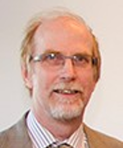
Peter Breger
Senior Expert in the Unit for “Copernicus" in the European Commission
Peter Breger is Senior Expert in the Unit for “Copernicus” in the European Commission. This unit implements and manages the space infrastructure and six operational services of Copernicus following the adoption of the Copernicus Regulation on 3 April 2014. Dr. Breger has been active in the Commission’s Space domain since 2002, as Deputy Head of Unit for Copernicus, as well as contributing to the precursor of Copernicus in its initial phases, and in implementing the Space theme of the EU Research Framework programme.
Prior to joining the Commission as Scientific Officer in 1998, Dr. Breger worked as experimental research physicist at the Nuclear Fusion laboratory JET Joint Undertaking in UK, and as a development engineer in industry.
Dr. Breger has a doctorate in Experimental Plasma Physics from the Ruhr-University Bochum, Germany, a Masters in Science in Atomic Physics, and an Electrical Engineering degree from the University of Cape Town, South Africa.
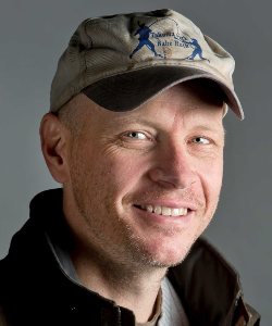
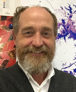
Matthew Hansen
Remote Sensing Scientist
Professor Matthew Hansen is a remote sensing scientist with a research specialization in large area land cover and land use change mapping. His research is focused on developing improved algorithms, data inputs and thematic outputs which enable the mapping of land cover change at regional, continental and global scales. Such maps enable better informed approaches to natural resource management, including deforestation and biodiversity monitoring and can also be used by other scientists as inputs to carbon, climate and hydrological modeling studies. As a member of the MODIS and Landsat science teams, his work employs and promotes freely available, globally acquired time-series imagery that serve to document global land change.
Anne Hale Miglarese
Founder and CEO of Radiant Earth Foundation
Anne Hale Miglarese is the Founder and CEO of Radiant Earth Foundation, a non-profit organization focused on applying machine learning on Earth observation to meet the Sustainable Development Goals – the world’s most critical challenges. Prior to launching Radiant Earth Foundation, Ms Miglarese served as President and CEO of Fugro Earth Data, as President and CEO of PlanetiQ and a Principal Director at Booz Allen Hamilton. In addition, she has worked for the National Oceanic and Atmospheric Administration, where she directed remote sensing and GIS programs for over a decade, and for several South Carolina agencies, including the Department of Health and Environmental Control, the Water Resources Commission and the Department of Natural Resources.
Ms. Miglarese is the founding chairperson of the National Geospatial Advisory Committee, and currently serves on the Boards of TerraGo Technologies and Waggoner Engineering, Saildrone Inc., and the NOAA Advisory Committee on Commercial Remote Sensing.
Professor Chris Justice
Co-Chair of the International GEOGLAM Initiative
Professor Chris Justice received his PhD from the University of Reading, UK in 1979. After obtaining his PhD he was granted Post-doctoral Fellowships with NASA and ESA, launching a career in satellite earth observation. He is currently the Chair of the Department of Geographical Sciences, University of Maryland. His research has a focus on the practical use of satellite remote sensing for societal benefit and he has developed satellite–based systems for global agriculture, fire and land use monitoring. His research has contributed to the development and use of time-series earth observation satellite data, starting with the AVHRR and subsequently with MODIS and now VIIRS. He has worked with NASA throughout his career, collaborating with scientists from NASA Goddard Space Flight Center. He is the Lead for NASA MODIS and Suomi-NPP VIIRS Land Discipline Team. He has been the Project Scientist for the NASA Land Cover Land Use Change Program since its inception and is the Chair of the NASA LANCE User Working Group. He is a member of the international GOFC-GOLD Fire Implementation Team. He is currently using satellite data to studying global agricultural production and drought, and is Co-Chair of the international GEOGLAM Initiative, endorsed by the G20 Agricultural Ministers. He is the science lead for the NASA Harvest Consortium, which is focused on the application of remote sensing to Agricultural Monitoring.
Alan Belward
Head of the Food Security Unit in the Directorate for Sustainable Resources
Alan Belward works at the European Commission’s Joint Research Centre in Italy where he is head of the Food Security Unit in the Directorate for Sustainable Resources. This team provides science advice for implementing, monitoring and evaluating the European Union’s Common Agricultural Policy and for the EU’s development cooperation with food insecure countries around the world. He has served on numerous international science panels including the UN sponsored Global Climate Observing System and was a member of the NASA/USGS’ Landsat Science Team from 2006 to 2017. He has a BSc in Plant Biology, a PhD in satellite remote sensing of the global environment and is a Fellow of the UK’s Royal Society of Biology.

Lori Garver
CEO of Earthrise Alliance
Lori Garver is the CEO of Earthrise Alliance – a philanthropic initiative established to fully utilize Earth science data to combat climate change. Garver is the former Deputy Administrator of NASA. She led the NASA transition team for President-Elect Obama and was his lead space policy advisor on the campaign. Previous senior positions have included General Manager of the Air Line Pilots Association, Associate Administrator for Policy and Plans at NASA and Executive Director of the National Space Society. Additionally, she is a Co-Founder of the Brooke Owens Fellowship, an educational organization providing internships and mentorship to collegiate women pursuing degrees in aerospace fields.

Zhe Zhu
Assistant Professor in the Department of Natural Resources and the Environment
Zhe Zhu is currently an Assistant Professor in the Department of Natural Resources and the Environment at the University of Connecticut, Storrs, CT. He is currently selected as the USGS-NASA Landsat Science Team Member (2018-2023) and EROS CalVal Center of Excellence (ECCOE) Science Interface Panel (2018-2021). He has pioneered methods to map land cover and land cover change algorithms using very dense Landsat time series and created cloud detection algorithms that are used by USGS for operational production.
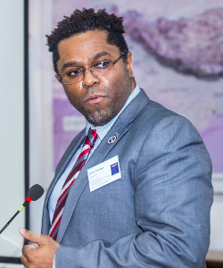
Emil Cherrington
Research Scientist with the University of Alabama in Huntsville
Emil A. Cherrington, PhD, is a forest ecologist and remote sensing scientist whose research interests include the mapping of forest and land cover types in Central America and French Guiana. In his position as a Research Scientist with the University of Alabama in Huntsville (UAH), he also serves as NASA’s Regional Science Coordination Lead for SERVIR-West Africa and as the alternate lead for the land cover, land use change, and ecosystems thematic service area at the SERVIR Science Coordination Office. He has been working with Landsat data for over 15 years.

Paulo Arévalo
Postdoctoral Research Associate in the Department of Earth and Environment at Boston University
Dr. Paulo Arévalo uses time series of satellite imagery to improve the mapping and monitoring of landscape dynamics and their effects on carbon emissions. He is currently a Postdoctoral Research Associate in the Department of Earth and Environment at Boston University. Dr. Arévalo is actively involved in projects that use Landsat imagery, including the mapping of land cover and land change at the global scale, and the comparison of detected land changes using Landsat and radar imagery in the Colombian Amazon. He provides technical assistance to countries that seek to improve their technical capabilities for land cover change mapping and greenhouse gas emission reporting. Dr. Arévalo is also interested in the potential of current space-born sensors for ecosystem and biomass mapping, and to inform decisions on biological conservation.
Please join us at the Baltimore Aquarium for the Pecora21/ISRSE 38 conference reception October 10th, 2019 for good food, drinks, entertainment and a tour of the World Reward Winning Baltimore Aquarium. Click here for more information on the Baltimore Aquarium.
IMPORTANT PARKING INFORMATION FOR PECORA21 * ISRSE 38 ATTENDEES
Parking: http://www.aqua.org/visit/baltimore/directions-parking
The Aquarium partners with the Lockwood Garage and the LAZ Garage. The Lockwood Garage is at 124 Market Place. The LAZ garage is at 100 S Gay Street, Baltimore, MD 21202. You would validate at the Aquarium for discounted parking at the garage. The machines for parking validation are located at the exit doors of the Aquarium.

